Introduction
Church Point is a vital part of life for the communities of Scotland Island and the Western Foreshores. Its ambiance, amenity and facilities are of major practical and social significance to offshore residents. It is also a space shared with many other users, both visitors and local residents.
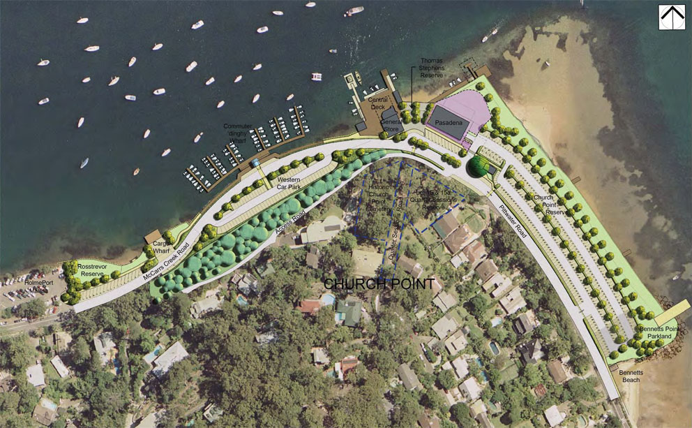
‘The Point’, as it is known by locals, is an active transport and social hub: ferries carry offshore residents to and from their homes, the Commuter Wharf provides mooring for the many commuter ‘tinnies’, locals and visitors gather for coffee and meals at the Waterfront Cafe, and residents pick up their mail and buy supplies.
Parking at Church Point has been a challenging issue for many years, and its environmental, social and economic aspects have been much debated. In 2009, the former Pittwater Council adopted a Plan of Management for the precinct, and in December 2013 voted to extend out the road and pedestrian walkway along McCarrs Creek Road, opposite the commuter boat wharf, and to build a 120-space carpark under the cliffside with other works to improve the amenities at the site.
In this section you can read a short history of the site, review the timeline of events, and access important documents relating to the site.
Links to some recent relevant documents
- Parking Issues Log
- Church Point Plan of Management (2009)
- Church Point Survey 2012 Short Summary
- Church Point Survey 2013 Results
- Visit other documents in our online Document Library related to Church Point Parking.
A brief history of the Church Point parking issue by Bill Gye
Introduction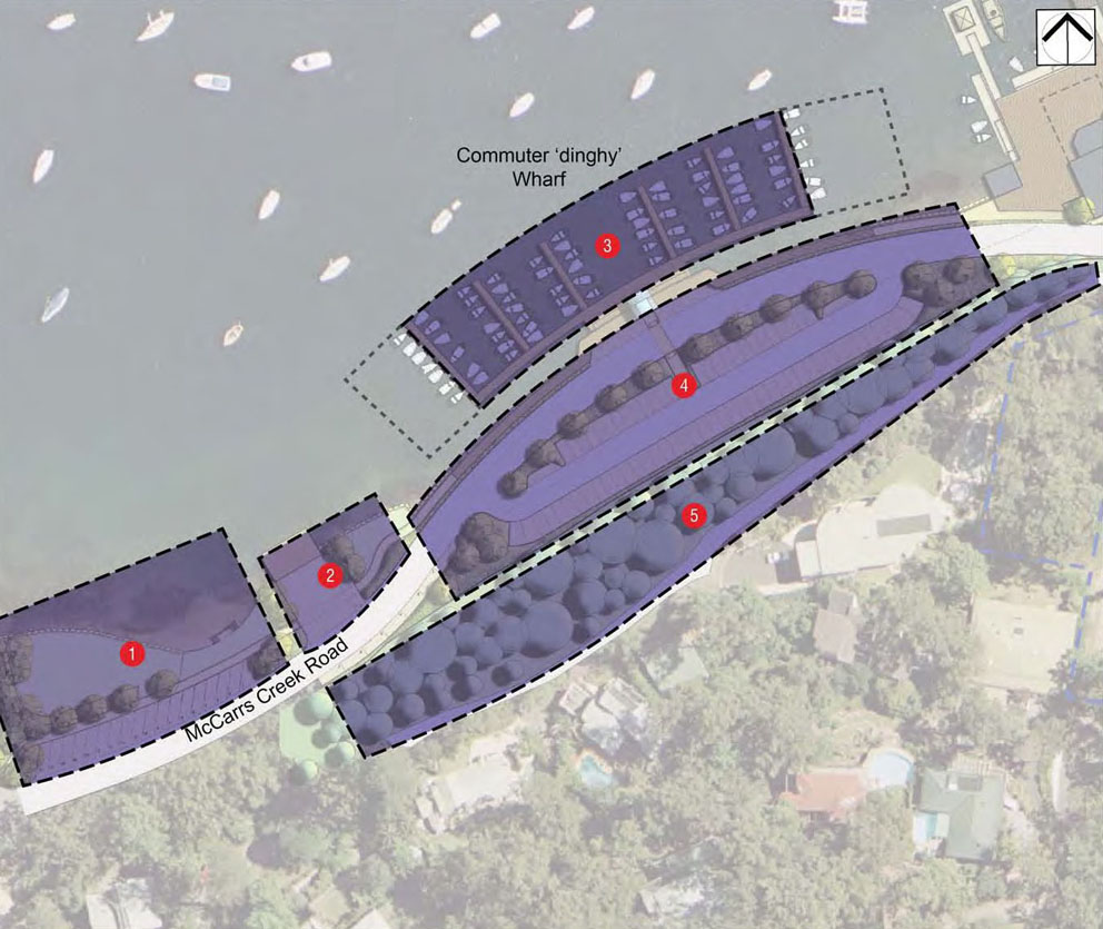
Church Point is the gateway for the 560 households that make up the offshore communities of Scotland Island and the Western Foreshores. Many of us pass through or spend some time at Church Point on a regular basis. Mooring a boat, parking a car (or trying to), catching a ferry, eating, drinking talking, mingling, picking up mail, or occasionally late at night waiting for collection by the water taxi, family or neighbour.
The offshore residential areas have grown and developed with little planning for infrastructure. A long term local problem has been the shortage of parking spaces, making it difficult for people to access their homes. In the latter part of the 20th century this was primarily only at peak times, but since then the problem has now become a daily one for those attempting to get home from work or study. Almost every night local parking is exhausted and a search for backstreet parking is required.
From the 1960s to 2008
In the early 1960s, the area known as the ‘carpark area’ at Church Point was ‘infilled’ for the purpose of car parking. In 1971, this area was reserved for Public Recreation purposes. In July 1995, this changed to Public Recreation and Urban Services (Parking). During the 1970s & 1980s, several community consultation processes, reports and design plans were undertaken in relation to Church Point. None were implemented.
Prior to 1988, there was parallel parking along the waterside of McCarrs Creek Road from the Waterfront Store to Cargo Wharf. In 1988, Warringah Council demolished the old stone wall, which remains as rubble strewn along the water’s edge , and constructed a narrower, boulder wall closer to the edge of the road, resulting in the loss of approximately 25 public car parking spaces.
In 1993, significant works were carried out in the carpark area. This rationalised the internal carpark layout and increased landscaping, creating carpark facilities for approximately 300 vehicles. These facilities are considerably less than the previous arrangements where up to 360 vehicles could be accommodated, albeit on a more ‘chaotic’ and informal basis.
In 1995, Pittwater Council prepared a Draft Management Plan for the main reserve. In 1997, further ‘maintenance’ work along McCarrs Creek Road, behind Holmeport Marina and further up the hill, resulted in the loss of approximately a further 15 parking spaces
Between 1997 and 2001, another series of minor works were undertaken in the carpark reserve, such as the introduction of pay and display, the addition of several disabled parking spaces, the inclusion of speed humps and the rationalisation of the space adjacent to the Pasadena. Though necessary, these changes also slightly reduced the available parking.
From 1997 to 2007, the Management Plan underwent a series of revisions and many further options were explored, including an underground carpark in the reserve.
Adoption of the Church Point Plan of Management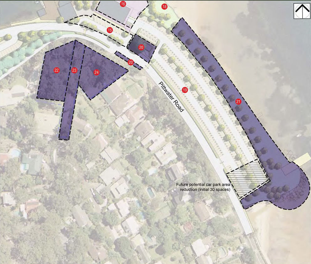
In 2009, a new and more comprehensive Church Point Plan of Management (POM) was adopted by the former Pittwater Council. This plan included a new vision for the centre of Church Point; a redesign of the existing overcrowded Commuter Wharf; the creation of an additional 60 parking spaces opposite the Commuter Wharf, with an option for an additional deck level (total 120 additional spaces); and the broadening of the green walkway in front of the main carpark reserve. The building of the additional infrastructure was supported in two large surveys of offshore residents and in discussions at several community meetings.
Implementing the Church Point Plan of Management
In 2012, the new Commuter Wharf was built and, in December 2013, the decision to proceed with the deck option was adopted by Council. In 2014 the local offshore and onshore resident associations met and agreed upon a common position on four demand management/parking arrangement strategies. This common position was communicated to Council in a joint letterhead communication. In 2014 GTA consulting were engaged by Council to provide a report on “Demand Management” strategies for Church Point. In October 2014 the application to the NSW Government’s Local Infrastructure Renewal Scheme (LIRS) for a loan subsidy was approved. This provides a 3% subsidy for any 10-year loan that Council takes out for this project.
In December 2015 Council received a detailed report on Church Point including the outcomes of the review of environmental factors, the report by GTA Consulting and also a number of recommendations from Council staff about changes to parking rules in the Church Point foreshore and surrounding streets (Eastview, Quarter Sessions and Baroona). The decision to proceed to tender was made and it is expected that the project will commence before the end of the financial year. Following concerns raised by Offshore Community Associations regarding some of the recommendations about changes to parking rules in the Church Point area, at the December 2015 Council meeting Councillors passed a motions requesting a further review and report on the future parking arrangements. This review should include considerations of possible exclusivity for Church Point Parking Permit holders in some areas at some times and considerations of exemption for this group from time limited parking in much of this area.
Timeline of Church Point parking developments
1920: Pasadena area infilled
1962: Main carpark area infilled
1971: Main carpark area gazetted for public recreation
1979: Bayview Church Point Foreshore Management Plan (proposed more infilling, not implemented)
1983: Open Space Reports (with several plans and options for parking)
1984: Commuter boat wharf reconstructed
1987: Cameron McNamara Report
1988: Demolition of old stone wall opposite commuter wharf (loss of 25 spaces)
1989: Church Point Revitalisation Plan (not implemented)
1993: Significant carpark makeover (loss of up to 60 spaces)
1994: CaLM Land reassessment of crown lands at Church Point
1996: Re-gazettal of main carpark for the purposes of public recreation AND parking
1994 – 1999: Several versions of a Management Plan for Church Point
1997: Council LEP Rezoning
1997: Maintenance work behind Holmeport Marina (loss of 15 spaces)
1998: Foreshore walkway constructed
1995 – 2005: Several above- and below-ground carpark designs investigated
2002: Master Plan Version 1 – Underground Option
2005: Threat to lose carpark
2006: Master Plan Version 2 – Parking along road site opposite commuter wharf
2007: GHD Review and Plan
2009: Church Point Plan of Management (CPPOM)
2011: First offshore survey
2012: New commuter boat wharf built
2013: Second offshore survey
2013: Council decision to construct the deck option
2014: Ongoing discussions about demand management and report by GTA Traffic Consulting
2014: LIRS (Local Infrastructure Renewal Scheme) loan subsidy from NSW Government approved
2015: Council decision to proceed to tender with the deck option
2015: Council request a further review of the parking arrangements in Church Point and surrounding streets
2016: Constructions to commence before July and the project take approx. 14 months
2018: New car park opened